
Hiking is not for the faint-hearted. And neither does everyone catch up a liking for it. But if hiking is your passion, you sure fall into that adrenaline-rush loving, adventurous clan!! For those who don’t like hiking, we have come up with a breath-taking list of hikes around the world that are so beautiful; you can’t help but pack off to one of these gorgeous destinations! And for the hiking-lovers out there, this is the ultimate checklist for you guys! Take a note, hike your heart out and then proudly strike them off your list! Off we go…
Tiger’s Nest
Tiger’s Nest is a Buddhist monastery that precariously seats itself at the edge of a cliff, 900 m above the ground. It is a pilgrimage which most people visiting Bhutan generally take. It offers a stunning view, amidst the chanting of monks and colourful prayer flags.
Country: Bhutan
Distance: 6.5 km
Time required: 4-6 hours
Perfect time: October to December
Difficulty level: Moderate
Parco Naturale Adamello-Brenta
Situated in the Dolomites, this stunning place is a must go for hikers. It is the perfect combo of lakes, forests, glaciers topped with ample of flora and fauna! There are plenty of easy pathways, but if you’re a severe mountaineer, get your harnesses and ropes and other gear along and conquer the Via Bocchetta di Tuckett!
Country: Italy
Distance: 14.5 km
Time required: 6-7 hours
Perfect time: July to September
Difficulty level: Easy/Difficult
Fitz Roy
Located on a mountain in Patagonia, this rugged location is adorned with striking rock-formations throughout. Go ahead, explore!!
Country: Argentina
Distance: 58 km
Time required: 4-6 days
Perfect time: November to April
Difficulty level: Easy
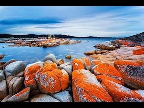
Bay of Fires
Pristine white beaches, clear blue waters and bright orange patched granite is a little gist of what this hike has to offer! Beautified with distinct flora and fauna, this hike is indeed a stunning slice of the Coast of Tasmania.
Country: Australia
Distance: 25 km
Time required: 4 days
Perfect time: November to March
Difficulty level: Variable
Robberg Peninsula
This place in Garden Route has managed to stun those who hiked around it for the first time! The circular path around the peninsula, not only gives you the thrill of a unique experience, but also a chance to witness the beautiful scenery around.
Country: South Africa
Distance: 11 km
Time required: 4-5 hours
Perfect time: February to April
Difficulty level: Easy
Queen Charlotte Track
This track is known to capture the true essence of New Zealand’s beauty! Lined with the native bushes, this hike gives you stunning view of the coastal line of this country.
Country: New Zealand
Distance: 70 km
Time required: 3-5 hours
Perfect time: September to May
Difficulty level: Variable
Mount Kilimanjaro
There’s a lot to Mt. Kilimanjaro than you feel- A dormant volcano and a beautiful mountain which also happens to be Africa’s highest mountain! A variety of flora adorns this mountain. And of course – the marvellous scenes!
Country: South Africa
Distance: Depends on your chosen route
Time required: 5-9 days
Perfect time: June to October
Difficulty level: Difficult
Great Wall of China
Walking across the Great Wall of China is indeed a memorable experience. This is because some of its sections are well maintained, others are distorted. You get to experience a variety of terrain throughout this hike.
Country: China
Distance: 10 km
Time required: 4-5 hours
Perfect time: March to November
Difficulty level: Variable
Croagh Patrick
One of the best hikes in the world, it also lists itself as an important Christian pilgrimage. It is also the most climbed mountain in Ireland owing to its beautiful scenic views.
Country : Ireland
Distance: 13 km
Time required: 1 day
Perfect time: April to October
Difficulty level: Very difficult
Israel National Trek
Ranging from the north to the south of Israel, this really long trek has a lot to offer! Right from the diverse flora and fauna of Israel to its culture and scenic views has made it one of the best hikes that one must try out!
Country: Israel
Distance: 1015 km
Time required: 45-60 days
Perfect time: February to May
Difficulty level: Moderate
What are you waiting for?? Explore and experience oneness with nature!!